Where Is Ecuador In South America-hidden In Plain Sight
- 01. Where is Ecuador in South America?
- 02. Key geographic context
- 03. Why the location matters for travelers
- 04. Historical snapshot
- 05. Current demographics and geography table
- 06. FAQ
- 07. Historical coordinates
- 08. Useful maps and visualization data
- 09. Practical travel tips keyed to location
- 10. Frequently asked questions
- 11. Geographic significance
- 12. Bottom line
- 13. Further reading
Where is Ecuador in South America?
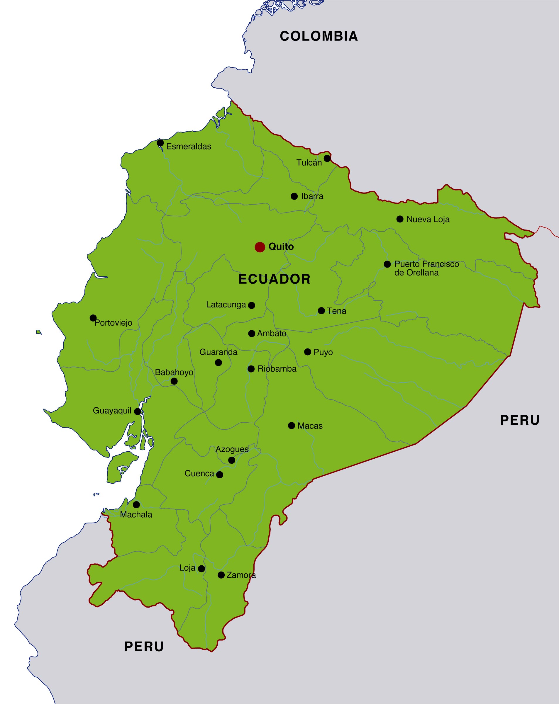
Answer: Ecuador is a country in northwestern South America, bordered by Colombia to the north, Peru to the east and south, and the Pacific Ocean to the west. Its mainland sits just south of the equator, and the nation also administers the Galápagos Islands about 1,000 kilometers (620 miles) west of the mainland. The capital is Quito, and the largest city is Guayaquil.
From a geographical perspective, Ecuador is part of the Andean region of South America, but its terrain spans three distinct ecological zones: the Andean highlands, the coastal plains (Costa), and the Amazon rainforest to the east. This triad creates a remarkable geographic diversity within a relatively small land area, which is roughly 283,561 square kilometers (109,484 square miles) for the mainland, with additional marine and insular territory including the Galápagos archipelago. The country's coordinates center near 2°S latitude and 77.5°W longitude, placing it squarely in the equatorial belt and contributing to its mild to warm climate year-round. Geography readers often note Ecuador's unique position on the equator as a defining feature that influences its climate and biodiversity.
Key geographic context
- Boundaries: Colombia (north); Peru (east and south); Pacific Ocean (west).
- Regions: Costa (coast), Sierra (highlands), Oriente (Amazon), and the Galápagos Province (islands).
- Capital: Quito, located high in the Andes at roughly 2,850 meters (9,350 feet) above sea level.
- Largest city: Guayaquil, a major port on the Pacific coast.
Historically, Ecuador's borders were established through a mix of colonial treaties and subsequent negotiations. The most enduring contemporary arrangement places Ecuador in the northwestern corner of the South American continent, balancing a mix of Andean culture, Amazonian biodiversity, and Pacific littoral economies. In 1830, when Ecuador became an independent republic, its territorial identity began to sharpen around these three principal regions, a pattern it maintains today in national planning and environmental policy. The Galápagos Islands, though remote, are a keystone in global biodiversity studies and tourism, underscoring Ecuador's maritime extent and ecological significance. Modern policy discussions frequently reference these territories when assessing national development and conservation strategies.
Why the location matters for travelers
Geographic placement affects weather patterns, altitude, and accessibility. The Andean highlands offer cool to temperate climates and dramatic urban altiplano views, while the coastal region provides tropical warmth and humid conditions, and the Amazon basin delivers hot, humid rainforests with abundant biodiversity. For travelers, this means options ranging from highland city tours in Quito and Cuenca to rainforest excursions in the Oriente and island hopping around the Galápagos. The equatorial position also means relatively consistent daylight hours year-round, with sunrise commonly around 6:00 a.m. and sunset near 6:00 p.m. in many locations. Travel planning guides emphasize altitude acclimatization for visitors heading to highland cities, especially Quito and surrounding towns.
Historical snapshot
- Pre-Columbian and colonial-era geography established early trade routes along the Andean corridor and coastal ports.
- Independent Ecuador (1830) defined its current tri-regional geography, with Galápagos later incorporated as a distinct province.
- 20th-century development programs focused on connecting highland and coastal economies, influencing infrastructure and tourism today.
Current demographics and geography table
| Aspect | Detail |
|---|---|
| Continental location | Northwestern South America, on the equator |
| Borders | Colombia (N), Peru (E/S), Pacific Ocean (W) |
| Main regions | Costa, Sierra, Oriente |
| Galápagos Islands | Isolated province ~1,000 km west of mainland |
| Capital | Quito |
| Largest city | Guayaquil |
| Total area | 283,561 sq km (mainland) |
| Average elevation | Higher in the Sierra; coastal lowlands common near the Pacific |
| Climate zones | Andean cool, coastal tropical, Amazonian humid |
FAQ
Historical coordinates
As of standard geographic references, Ecuador's center of gravity lies near 2°S, 78°W, a cartographic convention that helps standardize maps, aviation routes, and climate models. This is commonly cited in encyclopedic entries and national statistics to orient readers to the country's place on the planet. Coordinate data underpin many navigation apps used by travelers and logistics professionals.

Useful maps and visualization data
- Political map showing border lines with Colombia and Peru and the Galápagos Province highlighted.
- Physical map illustrating the Andes, Costa, and Oriente barriers and elevations.
- Tourism map marking Quito, Guayaquil, Cuenca, and major ecological sites (Amazon reserves and Galápagos).
Practical travel tips keyed to location
When planning a trip to Ecuador, consider altitude acclimatization if visiting highland cities; a typical stay for first-timers includes 2-3 days in Quito for altitude adjustment, followed by coastal or Amazonian excursions. For long-haul travelers, a Galápagos cruise offers a structured itinerary that minimizes the risk of jet lag and maximizes wildlife viewing opportunities. Finally, travelers should be mindful of regional rainfall patterns; the Pacific coast has a pronounced wet season from December through May, while the highlands experience cooler nights year-round, which informs packing lists and daily plans. Travel readiness hinges on understanding these geographic nuances to optimize safety and enjoyment.
Frequently asked questions
Geographic significance
Ecuador's location at the equator is not merely a line on a map; it has measurable effects on day length consistency, climate moderation, and biodiversity patterns across its regions. The Galápagos Islands, while distant, extend the country's marine and ecological footprint and have historically influenced global scientific thinking, from Darwin's observations to contemporary conservation science. This combination of equatorial geography and regional diversity has made Ecuador a focal point for researchers studying climate gradients and island biogeography. Equator positioning interacts with ocean currents and altitude to create microclimates that challenge conventional tourism and farming calendars alike.
Bottom line
In sum, Ecuador's placement in northwestern South America, with its three principal geographic zones and the Galápagos Islands, makes it a uniquely diverse country for travelers, researchers, and policymakers. Its location informs everything from climate and biodiversity to infrastructure planning and cultural exchange. Understanding "where Ecuador is" is a gateway to appreciating how geography shapes history, economy, and daily life in this compact yet richly varied nation. Geography remains the lens through which many analysts interpret Ecuador's development trajectory and ecological stewardship efforts.
Further reading
For readers seeking a concise, map-based overview, official geographic summaries from the CIA World Factbook and national government portals provide standardized coordinates and regional delineations. These sources corroborate Ecuador's position on the equator and its borders with Colombia and Peru while highlighting the Galápagos as a distinctive territorial unit. Official sources are recommended for precise, up-to-date border and demographic data.
Helpful tips and tricks for Where Is Ecuador In South America Hidden In Plain Sight
[Question]? What is Ecuador's exact location on the map?
Ecuador is located in the northwestern quadrant of South America, bounded by Colombia to the north, Peru to the east and south, and the Pacific Ocean to the west. The Galápagos Islands lie roughly 1,000 kilometers (620 miles) west of the mainland, forming a separate provincial jurisdiction. The nation's coordinates cluster near 2°S latitude and 78°W longitude, which places it just below the equator. This precise mapping helps geographers, travelers, and policymakers understand climate, biodiversity, and regional connectivity.
[Question]?
[Answer]
[Question]?
[Answer]
[Question]?
[Answer]
[Question]?
[Answer]
[Question]?
[Answer]
[Question]?
[Answer]