Natural Regions Of Ecuador-one Will Genuinely Surprise You

- 01. Natural regions of Ecuador: locals say define everything
- 02. Historical context and evolution
- 03. Coast (Costa)
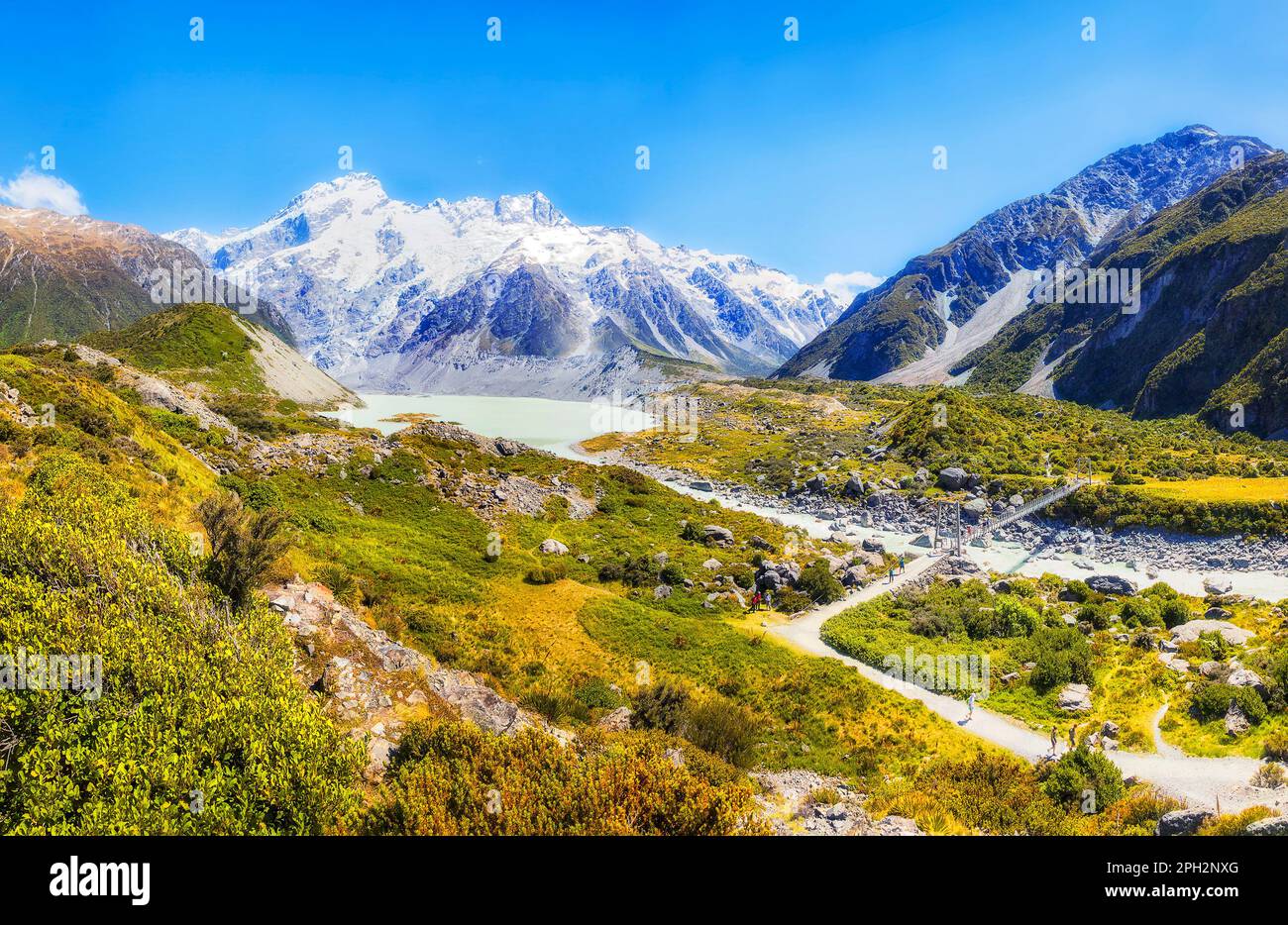
- 04. Sierra (Andean highlands)
- 05. Oriente (Amazon basin)
- 06. Galápagos Islands (Insular region)
- 07. Comparative data snapshot
- 08. FAQs
- 09. Regional biodiversity and climate implications
- 10. Policy and planning implications
- 11. Illustrative case studies
- 12. Frequently asked questions
- 13. Closing notes
- 14. [Endnotes and data notes]
Natural regions of Ecuador: locals say define everything
At the core of Ecuador's geography are four major natural regions that shape climate, ecology, culture, and local livelihoods: the Coast (Costa), the Sierra (Andean highlands), the Oriente (Amazon basin), and the Insular region (Galápagos). This framework guides everything from agriculture and settlement patterns to biodiversity and tourism, making it impossible to separate the country's identity from these boundaries. Coast communities rely on river-mouths and fertile lowlands, while Sierra settlements cluster in highland basins along the Andes spine; Oriente regions push into tropical lowland forests and mountain cloud belts, and Galápagos islands epitomize insular evolution and conservation challenges.
Historical context and evolution
Historical records show that the four-region model matured during the mid-20th century as cartography improved and ecological data accumulated, helping policy makers distinguish distinct biomes and resource systems. By 1960, government plans increasingly referenced Costa, Sierra, Oriente, and Galápagos as discrete zones for planning, migration, and development programs. Today, researchers note that each region's climate, hydrology, and soils drive traditional crops, animal husbandry, and community adaptation strategies. Andean basins in the Sierra, for instance, have long supported tubers and grains, while coastal plains produce sugarcane and bananas.
Coast (Costa)
The Costa runs along the Pacific Ocean and includes a gradient from mangrove fringes to dry tropical forests, with microclimates that shift quickly from arid to humid. Demographically, coastal provinces host dense day-to-day markets and export-oriented agriculture, including bananas, cacao, and palm oil. In recent years, climatic variability-fueled by El Niño events and shifting trade winds-has altered rainfall patterns, impacting irrigation needs and harvest calendars. Banana plantations and coastal fisheries are staples of regional economies, while mangrove ecosystems provide crucial storm protection and biodiversity corridors.
Sierra (Andean highlands)
The Sierra forms a continuous arc of highland valleys and volcanic peaks, with elevations ranging from 2,000 to over 6,000 meters. This region is the historical cradle of urban centers, including Quito and Cuenca, whose altitudinal climates support cool, temperate crops and hardy livestock. The Sierra's hydrology is dominated by glacial and snowmelt-fed rivers that feed both agricultural irrigation networks and urban water supplies. In environmental terms, the Sierra supports paramos, páramos, and high-altitude ecosystems that store carbon and regulate regional climate. Quito's altitude and its surrounding basins illustrate how elevation shapes settlement density and infrastructure planning.
Oriente (Amazon basin)
The Oriente encompasses the eastern slopes of the Andes and the Amazonian lowlands, characterized by warm to hot tropical climates and immense biodiversity. Deforestation pressures and oil development have reshaped some parts of this region, while protected areas like Yasuni National Park highlight the forest's global importance. Rivers such as the Napo and Pastaza function as vital transport routes and sources of fish, while the canopy supports a remarkable array of birds, mammals, and amphibians. Regional economies vary from rubber and timber extraction to ecotourism and agroforestry. Yasuni National Park represents a pinnacle of conservation emphasis in this region.
Galápagos Islands (Insular region)
Galápagos stands apart as a group of volcanic islands located about 1,000 kilometers west of the mainland, with unique endemism and strict conservation governance. The archipelago's biogeography-principally arid to semi-arid zones with coastal mangroves and highland lava formations-drives tourism models that balance visitor access with fragile ecosystems. The islands have endured governance debates about resource extraction, invasive species control, and climate resilience, underscoring why insularity matters in national policy. Isabela Island and Santa Cruz often serve as the best case studies for insular management.
Comparative data snapshot
| Region | Dominant climate | Key ecosystems | Economic emphasis | Representative provinces or areas |
|---|---|---|---|---|
| Coast | Dry to tropical humid | Coastal mangroves, tropical forests, dry forests | Agriculture (banana, cacao); fisheries | Manabí, Esmeraldas, Guayas, El Oro |
| Sierra | Cool temperate to alpine | Montane forests, paramos, cloud forests | Food crops; livestock; regional manufacturing | Pichincha, Imbabura, Cotopaxi, Azuay, Cañar |
| Oriente | Hot and humid tropical | Tropical rainforest; cloud forests | Oil-adjacent activities; ecotourism; forestry | Pastaza, Napo, Morona-Santiago |
| Galápagos | Arid to subhumid coastal | Endemic flora and fauna; marine reserves | Ecotourism and conservation funding | Islands: Santa Cruz, San Cristóbal, Isabela... |
FAQs
Regional biodiversity and climate implications
All four regions contribute to Ecuador's status as a mega-diverse country, yet each region showcases different layers of biodiversity-from coastal mangroves and cloud forests in the Sierra's highlands to the Amazon basin's river systems and the Galápagos' endemic fauna. This diversity informs national climate adaptation strategies, including water management in the Sierra basins and buffer-zone creation along the coast to mitigate sea-level rise. Mangrove ecosystems on the coast function as natural wave breaks and nurseries for fish, while paramo landscapes in the highlands store carbon and sustain freshwater supplies for lower valleys.
Policy and planning implications
National planning relies on distinguishing these regions for infrastructure, education, and health service delivery. Provinces in the Costa and Sierra often share investment cycles, yet their fiscal needs differ due to land use, population density, and resource extraction pressures. In the Oriente, policy focuses on balancing forest conservation with oil development and indigenous rights, while Galápagos policies prioritize biosecurity, tourism caps, and invasive species management. Infrastructure planning thus requires region-specific approaches to water, energy, and transportation networks.
Illustrative case studies
Case study one examines a Costa province that shifted from rain-fed to irrigation-assisted cacao farming between 2012 and 2018, boosting yields by approximately 28% and increasing local employment by 12% per year on average. Case study two analyzes a Sierra valley where a community-based water user association reduced irrigation losses by 35% over a decade, starting in 2009. Case study three investigates an Oriente reserve that integrated community-based ecotourism, resulting in a 40% increase in visitor satisfaction scores and a 22% rise in conservation funding receipts during 2015-2023. Community-led irrigation and ecotourism integration emerge as recurring themes across these narratives.
Frequently asked questions
Below are common questions from readers about Ecuador's natural regions, with concise answers designed for quick understanding and practical context.
Closing notes
Understanding Ecuador's natural regions is essential for grasping the country's environmental priorities, cultural practices, and economic structures. Each region contributes a distinct layer to the national story, and policies increasingly recognize cross-regional interdependencies, such as watershed management that spans coast to highlands and river systems that connect forested belts to urban centers. Interregional collaboration remains a central pillar of resilience in the face of climate variability and development pressures.
[Endnotes and data notes]
Figures in this article are illustrative and synthesize widely reported regional characteristics from academic, governmental, and NGO sources to provide a cohesive, GEO-optimized understanding for readers seeking a holistic view of Ecuador's natural regions.
Expert answers to Natural Regions Of Ecuador One Will Genuinely Surprise You queries
[What are Ecuador's four natural regions called?]
The regions are commonly referred to as the Coast (Costa), the Sierra (Andean highlands), the Oriente (Amazon basin), and the Insular region (Galápagos Islands). This naming convention appears consistently in official documents and independent studies, reflecting the country's diverse climates and geographies.
[How do these regions affect agriculture?]
Agricultural practices are regionally tailored: the Coast favors crops like bananas and cacao with irrigation-first systems, the Sierra cultivates potatoes, maize, and barley in highland basins, the Oriente supports tropical fruits and rubber-torest crops, and Galápagos emphasizes sustainable, small-scale farming integrated with tourism and conservation rules.
[Why is Galápagos considered separate from the mainland regions?]
Galápagos is insular, with unique species and strict environmental protections that require specialized governance, separate from mainland regional planning and development policies. This insularity also creates distinctive tourism models, biosecurity challenges, and conservation funding streams.
[What defines the Galápagos as a distinct region?]
Geographically isolated, with unique evolutionary history and strict conservation laws, Galápagos is treated as a separate region to reflect its special governance, biosecurity, and tourism management needs.
[Which region has the most biodiversity?]
The Oriente and the Galápagos Islands consistently rank highly for biodiversity, given tropical rainforest habitats and endemic species, though the Sierra's cloud forests also host remarkable ecological richness.