Location Of Ecuador On Map: Why It Matters More Than You Think
- 01. Location of Ecuador on map: why it matters more than you think
- 02. Where Ecuador sits
- 03. Why the map location matters
- 04. What the country includes
- 05. Key facts on the map
- 06. Historical context
- 07. How to find it fast
- 08. Why travelers care
- 09. Frequently asked questions
- 10. Why the map matters
Location of Ecuador on map: why it matters more than you think
Ecuador's location is on the northwestern edge of South America, directly on the Equator, with Colombia to the north, Peru to the east and south, and the Pacific Ocean to the west. The country also includes the Galápagos Islands, which lie far offshore in the Pacific and make Ecuador's map location unusually important for geography, biodiversity, and travel planning.
Where Ecuador sits
South American map readers usually find Ecuador in the upper-left portion of the continent, tucked between its larger neighbors and facing the Pacific coast. It is one of the few countries whose name is directly tied to its latitude: the Equator passes through the country, shaping both its national identity and how it is represented on world maps.
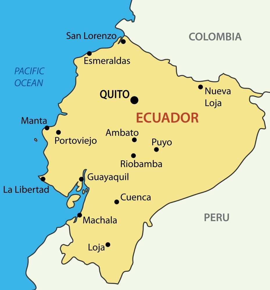
Geographic position also explains why Ecuador is often described as a compact but highly diverse country. Its territory spans coastal lowlands, the Andes highlands, Amazonian lowlands, and the Galápagos Islands, so its map location is not just a dot on the continent but a gateway to several distinct environments.
| Map detail | What it shows |
|---|---|
| Continent | South America |
| Relative position | Northwestern part of the continent |
| Western border | Pacific Ocean |
| Northern border | Colombia |
| Eastern and southern borders | Peru |
| Special territory | Galápagos Islands, about 1,000 km west of the mainland |
Why the map location matters
Equatorial location matters because it affects climate, daylight patterns, tourism branding, and scientific interest. Ecuador sits on the line that divides the Earth into the Northern and Southern Hemispheres, which is why the country is a frequent reference point in geography lessons and travel itineraries.
Pacific access matters because Ecuador is not landlocked; its coastline supports trade, ports, fishing, and tourism, while also connecting the mainland to the Galápagos region. That ocean frontage helps explain why Ecuador is strategically placed for shipping and marine ecosystems, even though it is smaller than many neighboring South American states.
What the country includes
National territory is more varied than many people expect from a simple map pin. Ecuador's mainland is commonly grouped into coastal, highland, and eastern jungle regions, and the Galápagos Islands form a fourth insular region that sits far out in the Pacific.
- La Costa, or the coastal belt, runs along the Pacific and supports major ports and lowland cities.
- La Sierra, the Andean highlands, contains Quito and many of the country's most famous volcanoes and mountain landscapes.
- El Oriente, the eastern lowlands, extends into the Amazon basin and is much less urbanized than the coast and highlands.
- The Galápagos Islands lie roughly 1,000 kilometers west of the mainland and are globally famous for wildlife.
Key facts on the map
National outline covers about 283,561 square kilometers, including the Galápagos Islands, and official reference sources place the capital, Quito, in the Andean highlands near 0 degrees 13 minutes south and 78 degrees 30 minutes west. These map facts help explain why Ecuador is often shown as a small but geographically complex country in atlas-style visuals.
Capital city Quito is not only the political center but also one of the world's highest capitals, which makes Ecuador's map location especially notable for elevation as well as latitude. The largest city is Guayaquil on the coast, reinforcing the country's split between highland administration and coastal commerce.
| Fact | Value |
|---|---|
| Official name | Republic of Ecuador |
| Capital | Quito |
| Largest city | Guayaquil |
| Total area | 283,561 sq. km |
| Location reference | Northwestern South America |
| Special island region | Galápagos Islands |
Historical context
Geographic naming is one of the most distinctive parts of Ecuador's identity. The country was named for the Equator, and that naming choice has remained central to how Ecuador is presented in educational materials, atlases, and tourism promotions.
Regional influence from the Andes, the Pacific, and the Amazon has made Ecuador a crossroads of cultures, ecosystems, and trade routes. Even though its land area is relatively modest compared with some South American neighbors, its map position gives it outsized importance in biodiversity and regional geography discussions.
How to find it fast
Quick map check is easiest if you scan the northwest side of South America and look for the country touching both Colombia and Peru while facing the Pacific. If you then look for the Equator crossing near the country's center, you have likely found Ecuador.
- Locate South America on a world map.
- Find the northwest corner of the continent.
- Identify Colombia above Ecuador and Peru to the east and south.
- Look for the Pacific coastline on Ecuador's west side.
- Remember that the Galápagos Islands sit far offshore in the Pacific.
Why travelers care
Travel planning depends heavily on Ecuador's map location because the country offers three distinct mainland travel zones and a remote island province. Visitors can move from coastal heat to cool mountain air to Amazon rainforest conditions within one country, which is one reason Ecuador is often considered unusually efficient for multi-environment trips.
Island distance also matters because the Galápagos are not close to the mainland in practical travel terms, even though they are politically part of Ecuador. Anyone reading a map of Ecuador should notice that the islands are separated by a substantial stretch of Pacific Ocean, which is essential for flight planning, cruise routing, and conservation policy.
"Ecuador is named after the Equator," which is the simplest way to remember why its map location stands out so strongly in geography discussions.
Frequently asked questions
Why the map matters
Geographic identity is where Ecuador's map location becomes more than a classroom fact. The Equator, the Andes, the Pacific coast, the Amazon edge, and the Galápagos together make Ecuador a country where location directly shapes climate, ecology, transport, and national image.
Practical importance shows up in everything from weather patterns to international travel to conservation science. If you know where Ecuador sits on a map, you immediately understand why it has such extraordinary variety for a country of its size.
What are the most common questions about Location Of Ecuador On Map Why It Matters More Than You Think?
Where is Ecuador located on the world map?
Ecuador is in northwestern South America, on the Pacific side of the continent, between Colombia and Peru. It is also one of the countries crossed by the Equator, which makes its location easy to identify on a world map.
Does Ecuador touch the Equator?
Equator line passes through Ecuador, and the country's name reflects that fact. Most of the country lies in the Southern Hemisphere, but its equatorial location is one of the clearest geographic markers used to identify it on maps.
What ocean borders Ecuador?
Pacific Ocean borders Ecuador on the west. That coastline is important for ports, fisheries, and access to the Galápagos Islands.
How far are the Galápagos Islands from Ecuador?
Galápagos Islands are about 1,000 kilometers west of the mainland, so they appear far away on most maps even though they are part of Ecuador. Their distance is a major reason the country is often shown with an inset map or separate island marker.
What countries border Ecuador?
Neighboring countries are Colombia to the north and Peru to the east and south. Those borders help define Ecuador's compact shape on the map and explain its role as a bridge between northern and southern Andean geography.