Ecuador Mapa Provincias Y Capitales You Can Finally Understand
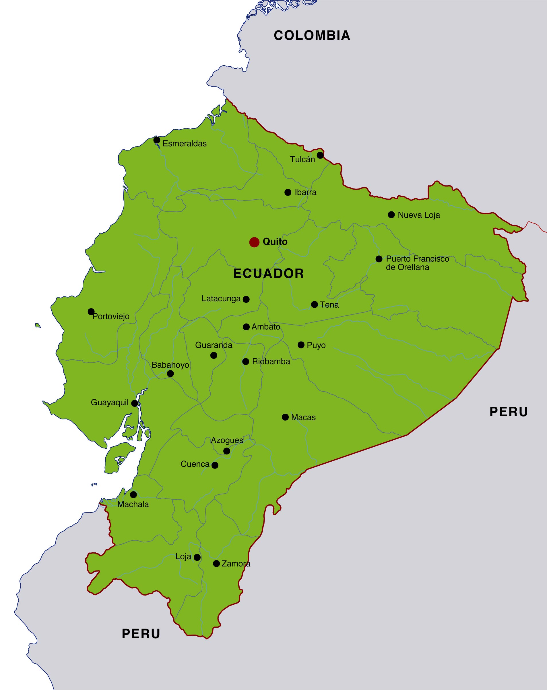
Ecuador Map Provinces and Capitals
Ecuador is divided into 24 provinces, and each province has a capital city that appears on any standard political map of the country; the most important anchors are Quito, Guayaquil, and Cuenca, which help orient the map quickly.
If you are looking for a clear "map of Ecuador with provinces and capitals," the simplest way to read it is by region: the Sierra runs through the Andes, the Costa lines the Pacific, the Oriente covers the Amazon basin, and the Insular region includes the Galápagos.

How Ecuador is organized
Administrative divisions in Ecuador are built around provinces, cantons, and parishes, but provinces are the easiest unit to identify on a country map. Ecuador currently has 24 provinces, and several sources continue to present that total consistently in modern administrative maps.
Geographically, the country is compact but highly varied, so a provincial map is useful not only for geography lessons but also for travel planning, regional reporting, and public administration. The Andes split the mainland into distinct east-west patterns, which is why map readers usually learn the provinces by region rather than one by one at random.
"A provincial map of Ecuador makes the country readable at a glance because the capital cities reveal the shape of each region."
Provinces and capitals
The table below gives a practical reference for the provinces and their capitals, which is the core information most people want when searching for "ecuador mapa provincias y capitales."
| Province | Capital | Region |
|---|---|---|
| Azuay | Cuenca | Sierra |
| Bolívar | Guaranda | Sierra |
| Cañar | Azogues | Sierra |
| Carchi | Tulcán | Sierra |
| Chimborazo | Riobamba | Sierra |
| Cotopaxi | Latacunga | Sierra |
| El Oro | Machala | Costa |
| Esmeraldas | Esmeraldas | Costa |
| Galápagos | Puerto Baquerizo Moreno | Insular |
| Guayas | Guayaquil | Costa |
| Imbabura | Ibarra | Sierra |
| Loja | Loja | Sierra |
| Los Ríos | Babahoyo | Costa |
| Manabí | Portoviejo | Costa |
| Morona Santiago | Macas | Oriente |
| Napo | Tena | Oriente |
| Orellana | Puerto Francisco de Orellana | Oriente |
| Pastaza | Puyo | Oriente |
| Pichincha | Quito | Sierra |
| Santa Elena | Santa Elena | Costa |
| Santo Domingo de los Tsáchilas | Santo Domingo | Costa/Sierra transition |
| Sucumbíos | Nueva Loja | Oriente |
| Tungurahua | Ambato | Sierra |
| Zamora Chinchipe | Zamora | Oriente |
Fast map reading guide
To read an Ecuador map efficiently, start with the three best-known reference points: Quito in the north-central highlands, Guayaquil on the Pacific coast, and Cuenca farther south in the Sierra. Those three cities are often enough to reconstruct the country's broad layout from memory.
- Locate Quito to anchor the Sierra in the north-central part of the country.
- Find Guayaquil to identify the coastal lowlands and the major port region.
- Use Cuenca to place the southern highlands.
- Check the Amazon-side provinces to the east of the Andes.
- Look west of the mainland for the Galápagos Islands and their capital, Puerto Baquerizo Moreno.
This sequence works because Ecuador's geography is not random; it is compressed north-to-south and sharply divided by elevation, making regional orientation easier than memorizing an alphabetical list. On a wall map, the provinces of the Sierra usually appear as a central spine, while the Costa spreads along the Pacific edge.
Regional structure
The country is commonly grouped into four natural regions: Costa, Sierra, Oriente, and Insular. That regional framework is helpful because it explains why some capitals are large coastal cities while others are inland administrative centers in the Andes or Amazon basin.
- Costa: Guayas, Manabí, El Oro, Esmeraldas, Los Ríos, Santa Elena, Santo Domingo de los Tsáchilas.
- Sierra: Azuay, Bolívar, Cañar, Carchi, Chimborazo, Cotopaxi, Imbabura, Loja, Pichincha, Tungurahua.
- Oriente: Morona Santiago, Napo, Orellana, Pastaza, Sucumbíos, Zamora Chinchipe.
- Insular: Galápagos.
For many readers, the most useful detail is that Guayaquil is the capital of Guayas, Quito is the capital of Pichincha, and Cuenca is the capital of Azuay. These three provinces also contain some of the country's most recognizable urban and economic centers.
Why this map matters
A provincial map is more than a school diagram because Ecuador's provinces frame transportation, trade, agriculture, and public services. Coastal provinces are tied closely to ports and export corridors, while highland provinces are linked to government, education, and inter-Andean commerce.
For travelers, knowing the province capitals helps with bus routes, airport planning, hotel searches, and weather expectations, since elevation changes sharply across short distances. For students, it is the fastest way to understand how Ecuador's geography shapes identity and daily life.
Useful reference facts
Modern reference sources consistently describe Ecuador as having 24 provinces, and one widely used administrative listing also shows the country's provinces alongside capitals, populations, and establishment dates. For example, that listing places Guayas and Pichincha among the most populous provinces, while Galápagos remains the most distinct insular province in the national system.
That same kind of table is especially helpful when you need to compare provinces on a single page instead of flipping between multiple map views. It also shows why a simple "province and capital" chart is still one of the most practical learning tools for Ecuador.
Historical context
Ecuador's province structure reflects long administrative change, with several provinces established in the 19th century and others created much later as population and governance needs expanded. That historical layering explains why some provincial capitals are older colonial centers while others are newer administrative hubs.
In practice, this means a map of Ecuador is not only geographic but historical: old Andean cities, coastal trading towns, Amazon frontier settlements, and island administration all appear together in one compact national frame. That combination is what makes the country's map unusually informative despite its small size.
FAQ
Practical takeaway
If your goal is to understand the capital list fast, start with the provinces most people recognize first, then use the regional pattern to place the rest. That is the easiest way to read Ecuador on a political map without getting lost in memorization.
For a quick mental model, remember this: Quito sits in the Sierra, Guayaquil dominates the Costa, Cuenca represents the southern highlands, and the Amazon provinces stretch eastward beyond the Andes. With those anchors, the whole map becomes easier to interpret.
Everything you need to know about Ecuador Mapa Provincias Y Capitales You Can Finally Understand
How many provinces does Ecuador have?
Ecuador has 24 provinces, and each province has its own capital city that is commonly shown on political maps.
What is the capital of Ecuador?
The capital of Ecuador is Quito, which is also the capital of Pichincha province.
What are the most important cities on an Ecuador map?
The most important orientation cities are Quito, Guayaquil, and Cuenca because they anchor the Sierra, Costa, and southern highlands on most maps.
Which province is Galápagos in?
Galápagos is its own province in the Insular region, and its capital is Puerto Baquerizo Moreno.
Why do maps group Ecuador by regions?
Maps group Ecuador by regions because the Andes, the coast, the Amazon basin, and the islands create natural divisions that are easier to read than provincial boundaries alone.